Saturday, April 30, 2016

Day 142: Two in One


Dawn on the Tenn-Tom

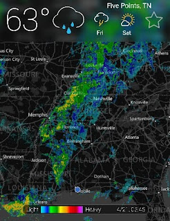
Last night's rains had a very immediate effect.  We anchored in a 1/2 mph current and woke to 1-1/2 mph current.  The river is up about 3' too.


Last Night's Weather Radar

It's not much fun being at anchor in a thunderstorm, especially in a narrow river.  We bow and stern anchored last night and did a poor job of it.  Properly done the bow anchor keeps the boat from floating down the river while the stern anchor keeps the boat from swinging into the river bank.  Our problem has been not letting out enough scope on the bow anchor.  Next time we'll set the bow anchor and then let out another 40' of rode.  Then the stern anchor will be dropped over the transom and its rode paid out while 40' of bow anchor rode is recovered. 


How quickly the River Rises

The run up the river was was slow.  At times we saw 3 mph currents.  By hugging the banks the worst of the current can be avoided.  That's a great strategy until you hit a sunken barge and sink your own boat.  Yup, that happened last year to a very experienced cruiser.


A Single Pin is Used While Locking

Today's 49 mile run saw us through two locks and two States.  At the dock in Columbus Marina, Columbus, Mississippi.  1618 miles to date.  DBH

Friday, April 29, 2016

Day 141: Hello Tenn-Tom


100' Selma Chalk (limestone) Mounds

As promised the Tenn-Tom is prettier than the Black-Warrior Tombigbee.  The terrain is higher, the river wider and the current is weaker.  But, it's also shallower. 


Inside the Howell Heflin Lock

Speaking of water depths, when cruising between the Chesapeake and the Keys, Nellie's shallow water alarm is usually set for 5'.  Since Nellie's aground at 3-1/2', a 5' alarm is the equivalent of a hair trigger.  Usually, no sooner does the alarm sound then we're aground.  Yes, the alarm's set point could be increased to 6' or 7', but then the alarm would always be soundings.  On the Black-Warrior Tombigbee the alarm was set to go off at 15'--three times deeper than on the East Coast!  Before we started this trip I never would have imagined that to be the case.


Railroad Bridge

On the hook about 50 miles south of Columbus, Mississippi.  69 miles today and 1569 miles to date.  DBH

Day 140: Duh!

Did you ever notice that men on cruising boats speak more kindly to their wives than non-boaters?  Asked of me today by Chuck Stiles, M/V Francesca.

Duh!  We knew there was soot getting below deck as we kept cleaning it up in the engine room. Problem was we couldn't find its source.  Today we did.  Right next to the Cummins wet exhaust thruhull is an abandoned diesel furnace thruhull.  This thruhull is high on the transom so I'd left it open to vent the lazarette.  Big mistake.  The Cummins engine is really a big air pump.  It draws in a lot of engine room air and exhausts it out the stern.  This means that air from all over Nellie moves towards the engine room.  It's that old 'nature abhors a vacuum' thing.  Bottom line, the lazarette vent was sucking in lots of diesel smoke.  Duh!


Tenn-Tom Waterway

The next small bite into this big trip will see us traverse the 10 locks of the 234 mile long Tenn-Tom Waterway from Demopolis, Alabama to Iuka, Mississippi.  At the northern terminus of the Waterway is the very scenic Tennessee River.

In Demopolis, Alabama.  1499 miles total. DBH

Wednesday, April 27, 2016

Day 139: Wildlife


A Snake on Neighbor's Prop


Turtles Everywhere


A Thunderstorm Passed Through at 1400

Nellie is reprovisioned.  Tomorrow is for boat projects.  If the river doesn't rise we start up the Tenn-Tom Friday.

In Demopolis, Alabama.  Holding at 1499 miles.

Tuesday, April 26, 2016

Day 138: Demopolis, Alabama


On White Bluff looking towards Demopolis Lock and Dam

Demopolis' Kingfisher Bay Marina is the first river marina at which we've stayed.  Our slip is on a new floating dock and undercover.  There's a pool, courtesy car, and chandlery.  At only $1.38/ft ($51.08/day) it's about half what we pay on the Chesapeake and yet has twice the amenities. 

A new starter motor and solenoid are on order and will be delivered to a marina about four days upriver. 

In Demopolis, Alabama.  No miles today and holding at 1499. DBH

Monday, April 25, 2016

Day 137: What's Burning?


Us, the Channel Marker and the Tug
We bow and stern anchored last night on the Tombigbee's left bank ascending (LBA).   We figured this was a safe place because (1) it was an inside corner after a fairly sharp upriver turn--push boats go wide in turns--and (2) we were on a bar outside the marked channel.  Within the hour the first push boat went by and showed us the error in our ways.  In order to navigate the tight bend a quarter mile down river, the push boat started turning to port before he got past us.  His stern, churning out lots of whitewater, got within 50' of Nellie.  On the VHF I asked the push boat's skipper if we'd been in his way.  Very politely he said, "A little.  You'd be better off 100 yards upstream." And then offered, "By the way, my buddy is right behind me."  Not wishing a repeat performance we quickly moved to the prescribed location.   Little did we know the evening's work had just begun.

Nose to the Grindstone
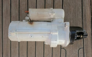
Something aboard was burning.  A quick check of the engine room revealed a dense, billowing cloud of white smoke coming off the starter motor.  Turning off the battery's master switch slowed and then completely stopped the smoke.  The immediate crisis was averted.  Now the problem was the engine wouldn't start, the boat had no electrical power--we were figuratively and literally in the dark--and we were 39 miles from the closest help. 

The Fried Starter Motor
Spoiler alert: we lived, the starter motor didn't!
It took four hours to diagnose the problem (the relay had stuck closed) and replace all the broken pieces.  At midnight it was a sweet sound when the  engine started.

Up the River
This morning, a bit weary and leary, we continued upstream.  A common sight, built-up sand bars on the inside corners and scoured banks on the outside corners. Nellie's speed was improved by favoring inside corners.

Demopolis Dam and Lock
The Demopolis Lock and Dam is a welcome sight at MM213.  This lock separates the Black-Warrior Tombigbee Waterway from it's allegedly more placid northern brother the Tenn-Tom Waterway.  They're both about equal in length but the Tenn-Tom has 5 times as many locks and thus supposedly offers a more controlled environment.  Having written that, why do I feel there's another lesson in the offing?

Welcome to Dempololis, Alabama
Demopolis marks the end of a very challenging section of the river.  I keep shaking my head in amazement at all the things we didn't know.  But, the last four days have been a graduate course full of valuable lessons in river navigation.
In Demopolis, Alabama.  39 miles today and 1499 miles into the journey.  DBH.

Sunday, April 24, 2016

Day 136: Coffeeville Lock and Dam


Early Morning Fog
This morning's fog was mostly patchy but at one point  the visibility dropped to under 100'.  Naturally, that's when the radar started picking up something big and just 1000' ahead.  I feared it was a tug with nine barges.  It turned out to be a 3' high channel marker.  Note to self, the size of the radar return doesn't always correspond to the size of the object.

Big Radar Return from a Small Red Nun
About six miles below the Coffeeville dam the river gets downright spooky.  It was the same erie feeling I got in Katrina-devastated Biloxi.  The flooding river had ripped the first 12' of leaves from every tree.   So consistent was the damage that it looked like the banks had a bathtub stain. 

The Bathtub Stain
The banks themselves were deeply scared and undercut.  Whole trees had fallen into the water and many more were in the process of doing so.

Errosion of the Soft Banks
The damage is a stark reminder of the river's power and a warning to all who ply these waters: beware, it only takes a little rain to wake this sleeping giant.

Coffeeville Lock (l) and Dam (r)
Nellie went through her first inland river lock today.  After writing about water heights at Coffeeville for two weeks, it was nice to finally see the lock.  It's like an old friend that I've never met before.  Here's the last time I'll report its gage height, we saw 22'. 

The Single Pin Tie Up
Different than the locks we've transited before, there was only one place to tie up to.  The 'pin' floats up and down with the lock's water level.  There wasn't much turbulence as we rose 20' and the single pin worked just fine. 
Cellular data is hard to find on the Tombigbee so I'll send this while we're still underway.  At MM154,  54sm today and 1438sm for the trip.  DBH

Saturday, April 23, 2016

Day 135: Up the River Down


Tensaw River Anchorage (note the wake coming from the anchor ball)
The trick in the 216 mile trip to Demopolis is finding good anchorages, i.e. places without tug traffic.  Last night's anchorage was on the Tensaw River about a mile down from where it intersects the Tombigbee at MM39.  The Tensaw is a nice wide, tree lined, placid river but with a 3 mph current.  Memo to self, sleep aft in current laden rivers as the noise will keep you awake.

Black-Warrior Tombigbee
It sure is nice having AIS.  While well out of visual range the tug Copper Duvall contacted as he approached the George Gaines horseshoe.  He recommended that we hold short as there isn't much passing room.  Right he was.
The river's current is slowly decreasing.  This morning our speed was 6 mph while this afternoon it's close to 7 mph.  A seemingly small difference, but it makes a long cruising day shorter.
In the still pond that is Old Lock #1, Tombigbee MM100.  67 statute miles (SM) today and 1384 SM to date.  DBH

Friday, April 22, 2016

Day 134: Alea Iacta Est


Downtown Mobile

We're underway and currently at Tombigbee MM4.  The current isn't  bad (.5kts) but there are lots of logs to dodge.  We really caught a break with the weather.  Current predictions are for falling river levels all the way to Demopolis MM216.


Dry Deck Day on the Bay

Mobile Bay was flat today.  Last year on this weekend seven sailors died when a freak storm whipped the waters with 90kt winds.


Navy Ships

We may not have much internet between here and Demopolis so I'll post this now.

At MM7 on the Tombigbee Waterway, still underway.  965nm to date.  DBH

Thursday, April 21, 2016

Day 133: We are Go for Launch!


Perfect Condions

The rain didn't materialize and the Tombigbee keeps dropping so tomorrow we'll untie the dock lines and head north.  We're following the sage advice of Fred Myers, author of the Tenn-Tom Nitty-Gritty Cruise Guide, who wrote:

It'll take us four days to make the 221 mile trip to Demopolis.  Tomorrow, after a thunderstorm blows through, we'll head up Mobile Bay.  Tombigbee MM0 is in downtown Mobile.  Our plan is to anchor at MM17. 

Nellie's provisioned and all systems are nominal. T minus 13 hours and counting.  In Fairhope, Alabama and 945nm into the trip.  DBH


Wednesday, April 20, 2016

Day 132: Wrong Way


Hmm, Not Good
Here's why the predicted water levels are rising.

Rain
It looks like it's raining in a lot of the Tenn-Tom's 2,200 square mile watershed.  Our launch countdown continues with the hopes that rain accumulation is less than predicted.

Abandon Ship!
This is a six person liferaft.  If you're not close with your mates you will be in this thing.  There's a saying, always step up to your liferaft.  In other words, don't get in the thing until it's higher in the water than the boat.  Stories abound of crews abandoning ship too early; the boat makes it and the crew doesn't.  That's a fine line and one I hope never to have to walk.  Certainly seeing one of these inflated and imaging myself bobbing around in it, strengthens my resolve to not get in one too fast.
So why was this $2,500 liferaft reduced to an inflatable toy?  Because life rafts have a shelf life and recertification costs almost as much as a new raft.

Working the Decks
All this time waiting for a river window hasn't gone to waste.  Today the teak decks received more attention;  failed caulk joints were replaced and rough areas were sanded.
Yup, Fairhope and 945nm--still.  DBH

Day 131: Boat Chores


Going Down

Looking good for a Friday departure.

Dropped the dink to replace the bow lifting strap.  Figured I'd run the engine.  It took awhile to get it started.  Boat stuff sure runs better when it's run often.

The helm had a slow hydraulic fluid leak.  The first step in the repair was to remove the steering wheel.  A gear puller was required.  The old o-ring was very stiff.  You don't suppose it's original equipment and is 29 years old?  A new o-ring is in place and if we ever move Nellie we'll find out if it's working.

Fairhope, Alabama.  Holding at 945nm.

Monday, April 18, 2016

Day 130: Hens Teeth


Coffeeville is Looking Good

Right now it looks like there will be a window opening on Friday which will allow us to start up the Tombigbee.  The predictions are for calm winds, a rising tide to help us up to Mobile, and acceptable gage heights at Barry Stream Plant MM30, Leroy MM97, Coffeeville Lock MM116, and Demopolis Lock MM213.


The Storm that Flooded Houston

One caveat on the 'go' prediction is the storm that flooded Houston yesterday.  It's currently working it's way east.


Coffeeville Gage, 1 Jan - 18 Apr

It helps to put things in perspective.  Since the first of the year there have been only two windows (the elongated dips in the above graph) when Nellie could have made it to Demopolis, Alabama, MM230.  Compared to 2012, 13, 14, 15, this year's windows have been like hens teeth: short and few.

In Fairhope, Alabama and holding at 945nm. DBH

Day 129: Nonlinear


Coffeeville Lock and Dam

It's hard being a river neophyte.  Yesterday's water level predictor line was nice and straight.  Extrapolating it showed that the water level would be at 12', the ideal height for our trip north, this Friday.  Today's graph shows the error of my way.  Rather than straight the predictor line is nonlinear.  Worse, it appears asymptotic about 17'.  So, the predicted water level will never reach 12'!  

We may be spinning our wheels waiting at this time of year.  I'll do some historical research on Coffeeville's gage height and get back with the results tomorrow.


A Well Marked Fairhope Trail

We were enjoying the hike until we came across this sign.

Still in Fairhope, Alabama and at 945nm.  DBH

Saturday, April 16, 2016

Day 128: High Math and Bungs


Going Down...

Come on 12'!  Our fingers are crossed that Friday will see us heading north.  We've hedged the bet by renting our slip for a month.  A month's rent is $15/day vs. $35/day if paying daily.  Breakeven is day 13.  That's Friday, the day we hope to leave.  If rains do come we'll have two weeks before more slip rent is due.


Dressed for War

Teak decks.  I love them.  I hate then.  Regardless, Nellie's require periodic maintenance.   Today I replaced 50 missing bungs.  Naturally, after all the tools were put away, I came across one bung that I'd missed.

Still in Fairhope.  Still at 945nm.  DBH


Friday, April 15, 2016

Day 127: Who is Henry George?


Coffeeville--Better Times Ahead!
The Coffeeville Lock and Dam, MM117 is the first lock we go through.  For a safe trip we need it to be around 12' high.  Extrapolating the forecast height, and assuming there's no appreciable precipitation, we'll be able to head north on Friday, 22 April.

Demopolis Dropping Fast
Upstream from Coffeeville is the Demopolis Lock and Dam at MM230.  By Wednesday it'll be at 22', a safe height for us. 
So, if all predictions hold, we should start up the river next Friday.  The current should be on the order of 1-1/2 mph and decrease all the way to Demopolis.

So Many Flowers in Alabama
Bicki and I thoroughly enjoy learning by ambling about.  Today that strategy took us into Fairhope's town museum.  Were we in for a surprise. 

Henry George
Fairhope was founded in 1894 as a utopian colony based on the economic principles of Henry George (1839-1897).   George believed in the common ownership of land and that there should only be one tax.  That tax should be based on the amount of land an individual uses.   Taxes on labor and capital, he opined, led to less labor and less capital.

Engraving on H. George Obelisk
Then, like now, a long recession had divided Americans into haves and have nots; it was Wall Street against main street.  Unlike now, the People's party, aka Populist Party, arose to compete with the Republican and Democratic Parties. 

1892 Political Poster
Many Populists believed that the 1890's recession was caused by Wall Streets' stranglehold on money.  Also, it didn't help that Congress had been flip flopping on the Reserve status of silver, because without silver there was less money in circulation.  This manifested itself in deflation, most notably in crop prices.  Not a good state of affairs when 50% of Americans are farmers.
By the 1896 Presidential election, the Populists had been absorbed into the Democratic Party.  It was their standard bearer, William Jennings Bryan,  that decried, "I will not help to crucify mankind upon a cross of gold." George's principals, which were front and center in the Populist's Party, had now taken a back seat. 
Henry George did have one lasting change on America: the secret ballot.  While traveling in Australia he saw it used and brought the idea back home.
George disavowed the Fairhope one tax experiment.  Not enough land he said.  The Corporation is still in existence today.  They own all of the downtown and half of the City proper. 

Waterfront Park and Rose Garden

Tree Lined Streets
Yup, we're still in Fairhope, Alabama and holding at 945nm for the trip. DBH